
Please read the Rules. This is an unsupported route. You need to be self-sufficient and are solely responsible for your actions.
The classic Tronsen Ridge / Devil’s Gulch loop just got bigger: by starting near Blewett Pass. This also means less driving if you are coming from the Seattle side. You’ll warm up by climbing a gravel road with great views of the Cascades. The first opportunity for single track is the Table Mountain trail, which you’ll ride via a couple other trails to the main event: the rowdy descent on Tronsen Ridge trail. A few punchy climbs will keep you warm here before it’s all smooth sailing down Red Hill trail. Afterwards, Red Devil and Devil’s Gulch will bring you back up to the ridge. From there, you’ll ride along the edge of the Mission Creek drainage on the Liberty Beehive gravel road. This small road with big views takes you to the last single track of the day: hike-a-biking up Mount Lillian which marks the highest point of the ride at 6100 ft. Unfortunately, the top is covered in trees, but a couple hundred feet down on your right is a meadow with an excellent view point. The Mount Lillian single track downhill is a bit rough, but nothing like Tronsen Ridge. Afterwards, you’ll head (mostly) down on gravel roads back to the start/finish, skipping the single track section from the beginning of the ride.
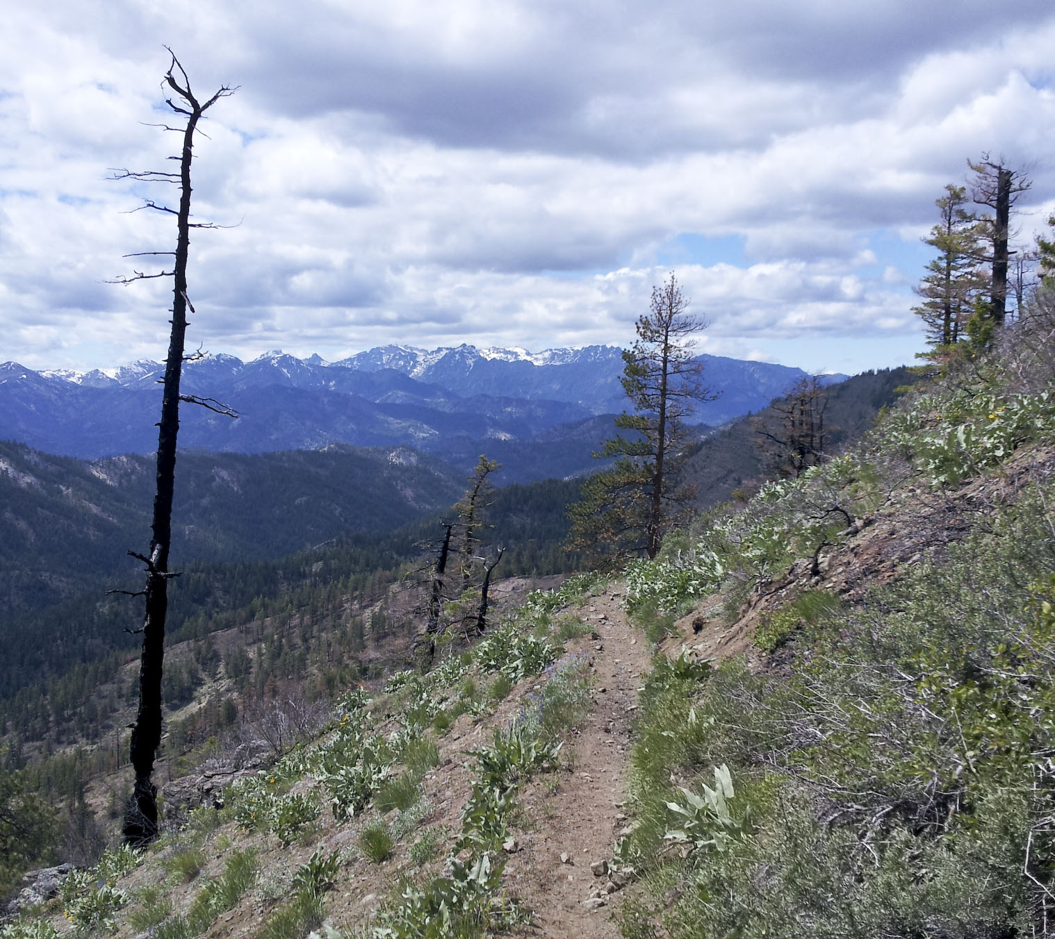
Along Tronsen Ridge.
When
Cancelled due to forecast for cold weather and rain
Saturday, 18 June, 2016, 9 am
Anticipated finishing times: 8-12 hours
Where
Start/Finish is at the Swauk Forest Discovery Trailhead near Blewett Pass. Parking requires a NW Forest Pass.

Devil’s Big Loop Start / Finish.
Route
56 miles (31 miles single track, the rest is dirt & gravel)
10,500 ft. elevation gain
Ride with GPS link to gpx track file
– Go on Export, then select TCS, GPX, or KML file format.
– No warranty, express or implied, use at your own discretion.
– Test that the file loaded correctly on your GPS device before attempting to ride.
– Do not rely solely on the track file. Bring maps and know how to use them.
- Take NF-9716 south to NF-9712. Take a left, go up and over the ridge
- Continue on NF-9712 to the first trail: Table Mountain trail
- Go up Table Mountain trail and continue onto a brief section of Mount Lillian trail
- Merge on Upper Naneum 4×4 trail going north, and after a sharp right, watch out for Tronsen Ridge trail on your left.
- Go down Tronsen Ridge and at 1st intersection go right on Red Hill trail.
- Stay left on Red Hill trail at the intersection with Red Hill Spur trail
- The northern end of Red Hill trail turns into Red Devil trail
- Take Red Devil trail going south, then continue on Devil’s Gulch trail going up (south).
- Once up on the saddle and at the intersection with Mission Ridge trail, stay left on Devil’s Gulch trail
- Ride Devil’s Gulch to the Liberty Beehive Rd. and take a right
- Ride Liberty Beehive Rd. heading west. Watch out for small trail sign for Mount Lillian trail.
- Take Mount Lillian trail to the top and down, then merge left onto Upper Naneum trail (you may not notice when you merge)
- At the intersection with the Liberty Beehive Rd. stay right and follow the gravel roads back to the Start/Finish.

Overview of Devil’s Big Loop

Total elevation gain is ~10,500 ft.
Water / resupply points
A lot of water is flowing in Mission Creek (along the Devil’s Gulch Trail). Naneum creek also tends to flow pretty well. No other sure resupply points are along route.
Bring some food, beverages and folding chairs for a post-ride gathering in the parking lot (the start/finish).
Registration
By signing up for a ride you are acknowledging that you are aware of the risks, dangers and hazards associated with this activity, and freely accept and fully assume all such risks, dangers and hazards, and further agree to release and discharge the Washington Endurance Series website maintainers against any and all liability arising from your participation in the activities.
If you have questions, use the comment field below.
No more than 74 people may ride according to the National Forest Service regulations.
As of 6-13, 4 people are signed up. Please register only once. The only confirmation that you will get will be the message “Thanks, your response has been recorded.” You will not get a link to see who else is signed up. You will also not get an emailed confirmation. If you need to make changes, fill out the form again and edit your Action.

Pingback: Tronsen Ridge – Devil’s Gulch Epic | 2wheeltrails
Pingback: Devil’s Big Loop endurance ride | 2wheeltrails
Planning for this in June. Heading over from Boise, probably solo. Going to camp nearby, any CG recommendations? Can I pay the day use fee at the Trailhead? Looking forward to it, been wanting to ride this area for awhile now.
Glenn
Glad to hear you’re coming. I have not camped there, but I see lots of people camping at the Swauk Discovery Trailhead: http://www.fs.usda.gov/recarea/okawen/null/recarea/?recid=57839&actid=50
Zoom in on the google map to see the tents. It’s not an official campground AFAIK, but it’d be pretty close and has an outhouse.
Another option would be to camp anywhere in the National forest, for example right in the big parking lot for the Tronsen Meadow trail. The ride starts a bit before that because the last bit of that road was somewhat washed-out last year and I didn’t want to drive anymore than necessary.
Forest passes in WA are a bit of a pain. Here’s a link where you can purchase a day pass: http://www.fs.usda.gov/detail/r6/passes-permits/recreation/?cid=fsbdev2_027009
Registration will open up next month. Cheers! Martin
Thanks for all the info..and for setting this up! Cheers!
The start/finish has been moved back to the Swauk Discovery trailhead. See you there.
I have signed up for the Devils loop ride June 20th, as of yet I have no partners. Any body want to meet at the start and ride together for a while?
Send me a email, dkinc10@gmail.com
You can get a view from the summit of Mt Lillian. There are a few rough trails that lead to the edge of her ~900 ft rock face. Be careful not to slip over the edge.
I have not received a confirmation email
Oops, misread the reg form
You’re on the list. There are 8 people signed up. See you Saturday!
Pingback: Summer Mountain Bike Events in the Northwest | evo
The route is available on trailforks:
http://www.trailforks.com/route/washington-endurance-series-devil-s-big-loop-2015/
To use it on iPhone, login to trailforks/pinkbike, then go to link above, click “wishlist”. Then start app on iPhone, login, go to “my routes” and swipe down to sync. The map is available for nav even when phone has no service.